Could the tide
fill an inland sea?
Give sunlight a coast of individual glass shells. Let every tide flood 500–1,000 acres at a time. Could enough of these passive districts supply a permanent freshwater lake for less than $100 billion?
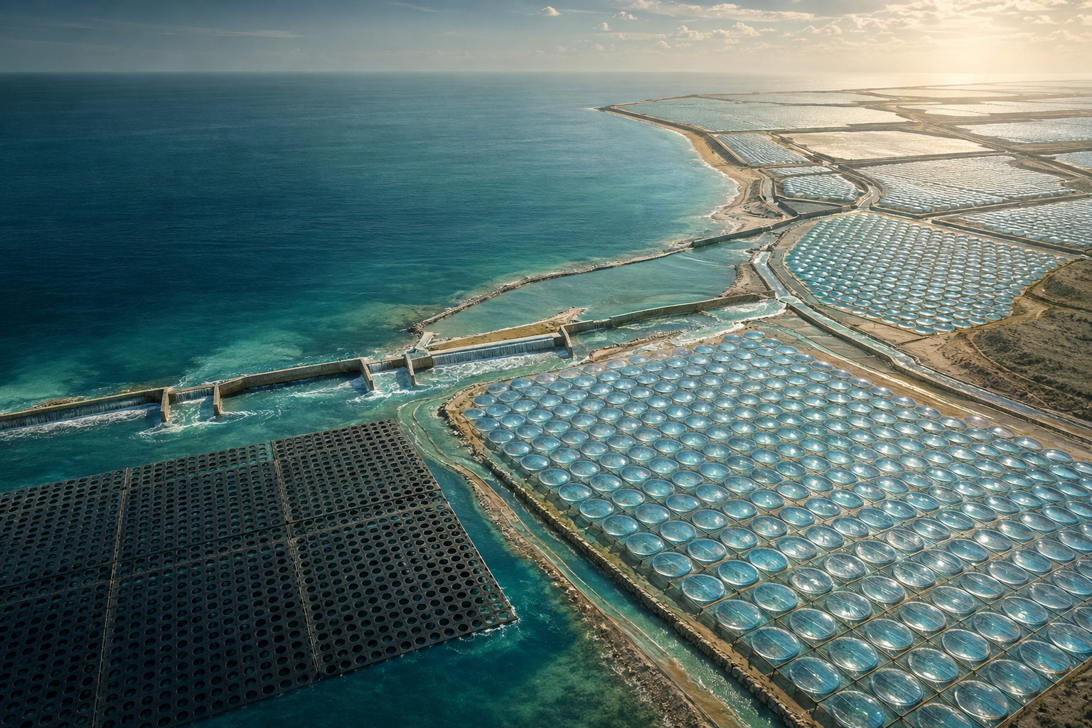
A bay rises beneath an enormous perforated blanket. Its upper layer reaches a high sluice and spills inland across a field of shallow cells. Each cell has its own low Fresnel shell. The sun distills the water; separate gutters collect the condensate. When the sea falls, a lower sluice opens under the water’s own weight and the remaining saline water leaves. The next tide begins again.
At the scale of one cell, the construction is modest: a basin, a cover, a shaded condensing edge, and three paths for incoming water, outgoing saltwater, and freshwater. At the scale of a coast, it becomes an immense repeating landscape. Tens of thousands of shells form one district. Thousands of districts could produce the continuous flow needed to fill and maintain an inland sea.
The premise is a passive coastal waterworks built around the sun and the tide. Its ambition is geographical: transform a suitable coastal fringe into a freshwater source large enough to sustain a Lake Eyre–scale water body. The shore supplies the water. An inland route must then carry it across the actual terrain.
Let the water level do the work.
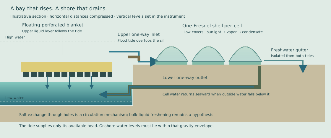
The upper inlet sits below a usable high tide and above the full cell water level. As the bay rises, its water overtops this inlet and runs down the distribution channels. A nonreturn flap prevents the same water from flowing backward through the high inlet when the tide turns. The lower outlet opens outward when the sea falls below the water held in the cells. Both actions follow pressure differences.
The floating blanket rises and falls with the bay. Its upper liquid layer meets the shore’s intake during the flood and drops away during the ebb. No coastal feed pump is assumed. The site must provide the elevation window: enough high-water head to fill the farthest cells and enough low-water clearance to drain them. Wider, gentler channels preserve more of that limited head.
Five hundred to a thousand acres is one district’s flooded footprint, including its cells and channels. A 750-acre district occupies about three square kilometres. At 78% shell coverage, eight-metre square cells give approximately 37,000 separate covers. Parallel districts share a coastline, while independent sluices let one section be isolated for repairs.
A skin over the bay.
The enormous sheet is a thermal blanket with holes. Warm water lies above it; the deeper bay remains a reservoir below. The holes allow circulation, exchanging water and carrying accumulated salt away from the heated surface. Floats and flexible joints would let the sheet follow the tide across a protected bay.
The proposed upper layer is a few feet deep. The question is whether thermal structure and circulation can create a useful layer for the rising tide to skim into the shore system. Its salinity, temperature and volume at the sluice are quantities to measure.
The closest research precedent is the 2022 wick-free confined-water-layer study. Its perforated insulation localizes heat while natural convection rejects accumulating salt to the reservoir. The experimental heated layer was about 5 mm deep, with millimetre-scale holes. That supports the circulation mechanism; it does not demonstrate a few feet of fresh liquid above a bay.
The physical proposal therefore keeps the large floating layer and tidal transfer, while the present production calculation credits freshwater only when vapor condenses in the shore cells. Any demonstrated liquid freshening would become a measured benefit of the first stage. A lighter warm layer and a freshwater layer are different properties, and a depth-resolved salinity measurement can tell them apart.
One cell. One shell. An entire coast.
Each Fresnel shell sits close over its own shallow cell, with its rim following the cell perimeter. Concentric or segmented optical facets direct sunlight toward the heated water surface. The small enclosed vapor space leads to a shaded condensing margin and a protected freshwater gutter. The cover’s footprint supplies the solar aperture; concentrating its light does not increase the total energy intercepted.
Separate cells make the coast manufacturable. Covers can be molded, nested for transport, placed repeatedly, and replaced one at a time. Small unsupported spans reduce the structural burden. The tide renews the saline feed and provides an ebb rinse. Local cell walls keep a damaged cover from becoming a district-wide failure.
The cold side belongs inside this passive construction. A shaded rim or seaward-facing condensing surface must lose heat to the environment fast enough to collect vapor. Its area and thermal contact determine output alongside the optical shell. The working model exposes one net solar-to-collected-water efficiency rather than assuming a powered cooling circuit.
Thousands of districts become a river.
A permanent inland lake needs a permanent replacement flow. The reference lake covers 9,500 km² and requires an assumed 30 km³ initial fill over twenty years. With the selected evaporation, rainfall and seepage, the lake loses 23.28 km³ each year. Filling, a freshwater flushing outlet, and delivery losses bring the coastal requirement to approximately 28.61 km³/year, or 907 m³/s.
The initial passive calculation gives roughly 7,900 m³ per day from one district, using 6 kWh/m²/day of sunlight and a 65% net collection efficiency while cells are wet. It integrates ideal tides against daylight for a month. Dry intervals and reheating after a cell drains reduce the result to about 3.3 liters per square metre of shell aperture per day. These are chosen engineering assumptions, not field measurements.
At that yield, the lake requires approximately 30,000 km² of shore districts and hundreds of millions of individual shells. An equal-footprint offshore blanket would add another roughly 30,000 km². A coastline with several kilometres of usable width still requires thousands of kilometres of deployment. This is the scale the premise has to confront; a single thousand-acre field is a repeating unit within it.
The district model deliberately lets every tide enter and leave. It consequently reveals when a falling tide empties cells during good sunlight. Sill levels, retained depth and passive outlet geometry are design variables. Improving the overlap between water and sunlight can raise useful output without changing the basic energy source.
Can repetition make it cheap enough?
The $100 billion question is a manufacturing question as much as a solar one. A field of this size needs very inexpensive installed area. The cell allowance includes its low shell, basin, condensing margin and gutters. Earthworks, channels, blanket deployment, coastal protection, and inland conveyance all compete for the same budget.
At the initial screen’s area, a $12/m² complete-cell allowance and $2/m² district earthworks allowance already put the project well above $100 billion. With a $20 billion reserve for the offshore blanket, inland route and other works, plus 20% contingency, the illustrative initial total is about $435 billion. This is an allowance calculation, with substantial unresolved scope. It is not a construction estimate.
The exhibit solves backward for the installed cell cost compatible with $100 billion. Under those initial settings, almost all the available budget goes to shore works and the other-works reserve. The premise needs some combination of greater measured collected yield, less expensive prepared area, a more favorable site, and radically cheaper repeated construction. Reducing the size of the destination lake would answer a different question.
Heat reuse remains a possible passive extension, but the present screen gives the cells one evaporation and condensation pass. Additional condensation stages must earn their collection rate and material cost in an actual shell before they are used to shrink the coastline on paper. Equally, useful pre-separation in the bay must be measured before it receives an energy or production credit.
What would settle the premise?
A bay trial should follow one floating perforated section through full tides. Measure temperature and salinity from the surface down through the proposed upper layer, the exchange through the holes, and the water that actually crosses the high sluice. That establishes whether the bay supplies warm saline water, a reduced-salinity layer, or something more useful—and whether the flood preserves it.
A complete cell then has to collect water through sun, cloud, wind, salt deposits and ebb rinsing. Measure condensate rather than evaporation alone. Its shell should be removable, its gutter protected, and its cold surface passive. A connected bank of cells should demonstrate that the two-height sluices fill and drain the entire bank without powered feed or timed gates.
The first district tests the landscape: sediment moving through channels, storm survival, blanket mooring, maintenance access, tidal timing, and installation cost per occupied square metre. Scaling proceeds by repeating the same working unit. The immense bay blanket and the individually replaceable shells remain the architecture throughout.
The inland sea has its own water and salt balance. Existing lakebed salt, saline groundwater, route high points, evaporation, and a permanent salt outlet must be surveyed. Kati Thanda–Lake Eyre is also a protected, culturally significant landscape. The geographical ambition deserves a specific destination and route, with the living landscape understood as carefully as the coast that would supply it.
Research trail
- Zhang and colleagues, Highly efficient and salt rejecting solar evaporation via a wick-free confined water layer (2022). Perforated thermal insulation and natural circulation beneath a thin heated layer.
- MIT: Solar-powered system offers a route to inexpensive desalination (2022). Explanation of the floating layer, macroscopic holes and salt-rejecting circulation.
- Gao and colleagues, Extreme salt-resisting multistage solar distillation with thermohaline convection (2023). A separate research direction for passive heat reuse.
- Australian Water Outlook: historical water-balance data. Selecting appropriate evaporation and rainfall records.
- Kati Thanda–Lake Eyre National Park. The proposed scale refers to a real, protected and culturally significant place.