A mountain
that makes
clouds.
A solar chimney rises from a Pacific lagoon, lifting warm marine air toward the cloud layer. Could a built wonder become a useful influence on the ocean’s heat?
Clipperton plan fit · geometry rendering · structural system unresolved
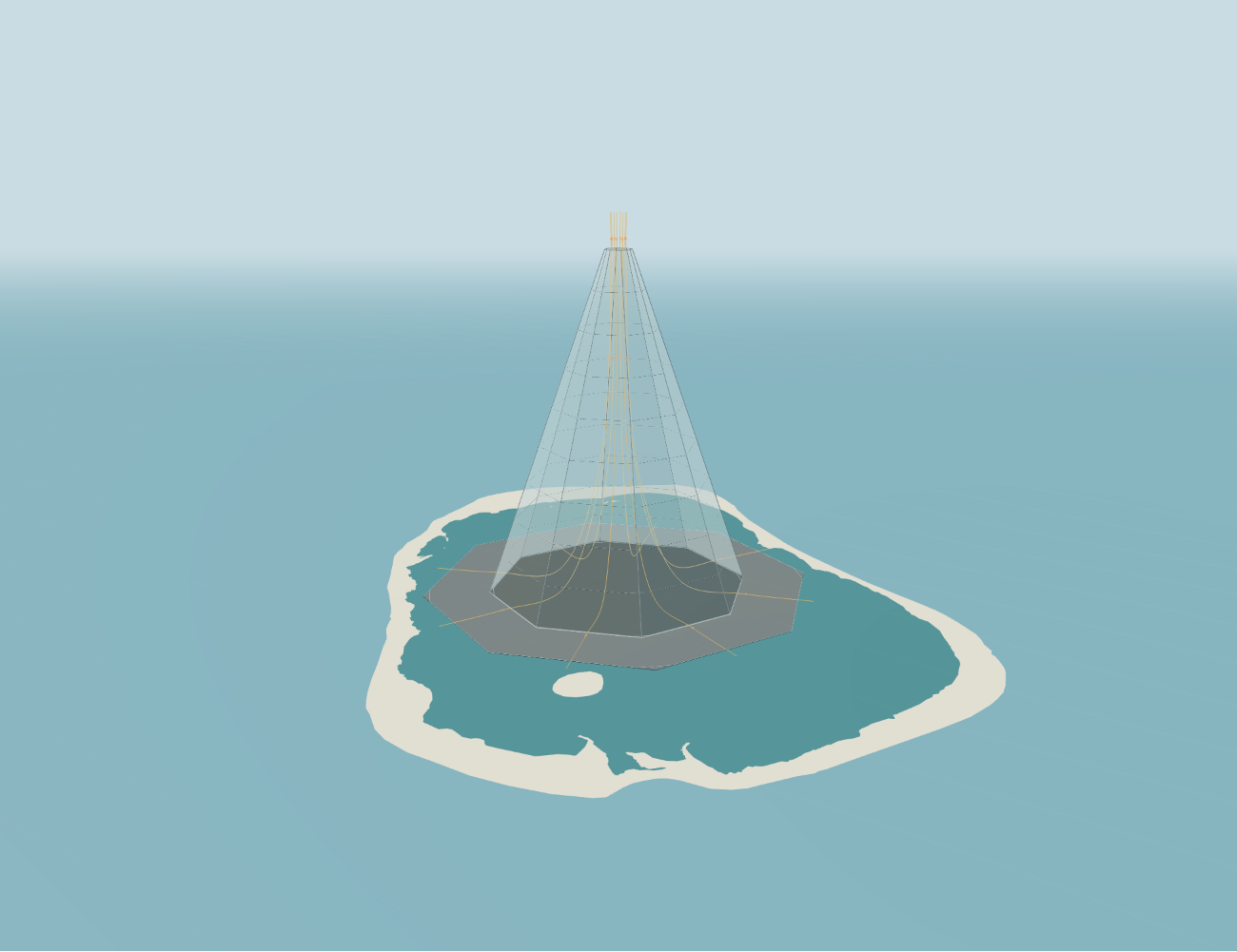
The mountain is hollow. Its eight translucent faces rise around an open summit; a broad black skirt floats outside its base. Sunlight heats the dry collector and the floor beneath the canopy. Marine air moves inward, warms, and rises. As pressure falls, the air expands and cools. Some of the water it already carries becomes cloud.
The ambition is larger than a local plume: establish a persistent source of cloudy air, let favorable atmospheric conditions help it grow, and investigate whether the resulting sunlight reflection could influence Pacific heat storage and El Niño. Each step has its own physics. The interactive Solar Volcano exhibit exposes the geometry, heating assumptions, airflow, and loads; the proposal here follows that air into the climate question.
A footprint the lagoon can hold
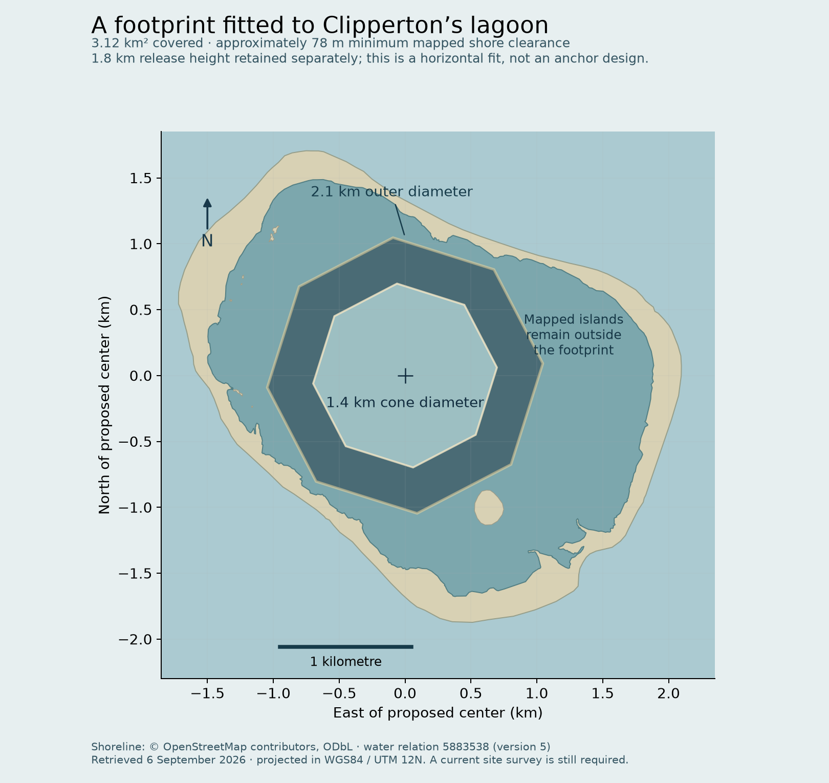
Clipperton’s enclosed lagoon offers a sheltered water surface, but its irregular outline decides the size. An octagonal footprint with a 700 m cone radius and a 350 m skirt fits wholly inside the mapped water, excluding the islands. The outer diameter is 2.10 km across opposite vertices; the combined footprint is 3.12 km².
The placement leaves about 78 m to the nearest mapped shore. It uses the same two-to-one relationship between cone radius and skirt width throughout. A numerical search allowed the center, rotation, and size to vary, then rounded the result down to a practical geometric dimension. It establishes a fit against this shoreline dataset; it does not establish anchor locations or a foundation.
The summit remains 1.80 km high, with a 140 m opening. Keeping the release altitude while narrowing the base makes the nominal cone angle about 70.7°. It is a much steeper mountain.
Sunlight supplies the lift
The skirt is a dry absorber, so it adds heat without adding evaporation. The water in the plume enters as humidity in the marine air. Beneath the cone, a black floating floor absorbs transmitted sunlight. The membrane, floor, and air have separate heat budgets: a warm surface cannot be credited with more sustained heat than its sunlight, insulation, and storage can supply.
For an illustrative inlet of 30°C and 80% relative humidity, 900 W/m² sunlight, and prescribed 60°C collector surfaces, the steady model finds about 125 tonnes of moist air per second. Air leaves the skirt at 32.0°C, reaches 33.5°C after the inner floor, and cools to 21.2°C at the summit. The exit speed is 9.3 m/s. Condensation starts near 960 m; about 255 kg/s of suspended liquid reaches the opening, within a total water flux of 2.64 tonnes/s.
Those are favorable input assumptions, not measurements of Clipperton’s typical weather. Holding a floating absorber at 60°C requires insulation and a complete surface-energy balance. Lowering inlet humidity to 65% reduces the calculated condensate to about 91 kg/s. The model includes expansion cooling, latent heat, droplet weight, and losses, but treats the air as a steady one-dimensional flow.
The exhibit opens on the Clipperton fit. The larger Minamitorishima reference cases remain available for comparison.
A cloud can grow—or disappear
A moist plume can recruit surrounding water. If buoyancy carries mixed air higher, the fall in pressure cools it and permits more condensation. Latent heat then helps sustain the ascent. The opposing process is entrainment: mixing drier outside air into the plume evaporates droplets and can remove its buoyancy. Cloud formation here relies on lifting humid air and existing atmospheric condensation nuclei; no extra aerosol source is assumed.
A fixed-pressure calculation isolates that competition. At 825 hPa, mixing the summit flow with 18°C, 80%-humidity air gives the results below. The calculation carries the source’s dry air along with its water, conserving both mass and moist enthalpy. The source is first equilibrated at the comparison pressure, which slightly changes its liquid fraction.
| Ambient dry air added | Mixed temperature | Liquid water content | Liquid carried |
|---|---|---|---|
| 0 tonnes/s | 21.2°C | 2.02 g/m³ | 261 kg/s |
| 100 tonnes/s | 18.8°C | 0.75 g/m³ | 175 kg/s |
| 200 tonnes/s | 17.9°C | 0.24 g/m³ | 81 kg/s |
| 285 tonnes/s | 17.4°C | Approaches zero | Approaches zero |
The last row is the evaporation boundary, not a dense cloud. At an assumed horizontal transport speed of 13 mph, its volume flux would occupy an equivalent circular section about 304 m across. That is a dimensional comparison, not a prediction of plume width. Neither the summit speed nor a water-flow rate determines the downwind cloud area.
Allowing the plume to rise gives another conditional result. With a middle entrainment coefficient of 0.10, the Clipperton source reaches about 2.35 km total altitude beneath the test inversion, or 2.55 km in the steadily stable test atmosphere, before upward speed falls to 0.2 m/s. These are maximum-rise proxies; lateral spreading can begin lower. A real sounding, crosswind, rainfall, and cloud microphysics decide whether the cloud persists, broadens, or evaporates.
How far does the cloud travel?
A downstream calculation follows the rising plume into crosswind, then lets its water and heat spread, condense, evaporate, and lose droplets to drizzle. It uses 48 representative sunny profiles from the 2025 archived GFS weather near Clipperton, recalculating the tower for each atmosphere. Two prescribed collector temperatures, three mixing assumptions, and two initial wake shapes produce 576 conditional cases. They describe a spread of physical possibilities, not measured weather odds.
The result ranges from rapid evaporation to a narrow cloud ribbon tens of kilometres long. With the middle mixing assumption, about half the cases produce no substantial downstream cloud. Favorable humid conditions preserve a few square kilometres; a cautiously optimistic episode reaches 5–20 km² of cloud over roughly 15–35 km downwind.
| Operating episode | Cloud footprint | Downwind reach | Extra solar reflection |
|---|---|---|---|
| Rapid evaporation | No substantial wake | Local plume only | Approximately zero |
| Favorable | 1–5 km² | About 5–20 km | About 0.3–1.3 GW |
| Cautiously optimistic | 5–20 km² | About 15–35 km | About 1.5–5 GW |
These rounded ranges describe a simultaneous cloud footprint during steady sunny operation. The cloud threshold is 10 grams of liquid water per square metre of sky. The optimistic ribbon is typically only about 400–900 m wide. Its reflected power redirects sunlight falling across the cloud; it is not electrical generation. An approximate allowance for atmospheric transmission and infrared warming puts that band's net daytime cooling around 0.5–5 GW. Neither figure is an annual climate benefit.
Humidity decides much of the outcome. Reducing downstream relative humidity by five percentage points shrinks two large calculated fields from 28 to 12 km² and from 22 to 4 km². The largest sampled tail reaches about 34 km² and 55 km downwind, but some clouds still persist at the six-hour calculation limit. Two nearly calm cases fall outside the wake model altogether. Conservation and finer-resolution checks pass; real cloud turbulence, evolving winds, droplet formation, and regional weather feedback remain unresolved.
Night has an energy bill
Continuous operation is possible only with an adequate stored or external energy supply. In a pressure-work screening calculation, removing prescribed absorber heating and the solar terms while forcing the same daytime mass flow requires about 22 MW of fan electricity at 70% fan efficiency. Twelve hours consumes roughly 262 MWh; at 85% storage round-trip efficiency, charging requires about 308 MWh.
A 3 MW generator running for twelve daylight hours produces 36 MWh, delivering about 31 MWh after those storage losses—enough for roughly 1.4 hours at that fan demand. A turbine extracting energy from the daytime updraft would also change the daytime flow. The model’s 5.4 MW of outlet kinetic power is an energy scale, not an independently available electrical yield.
Thermal storage, a lower night flow, and a separate power source are alternatives to investigate. This night calculation holds the daytime outdoor profile fixed and omits retained heat and fan-heat feedback, so it is not a complete night operating design. More fundamentally, clouds reflect no sunlight at night and can retain outgoing infrared energy. An operation optimized for net cooling may deliberately follow the Sun.
From one plume to the Pacific
The climatic purpose is to change the ocean’s energy balance where and when that change matters. El Niño is a coupled evolution of sea temperature, winds, and upper-ocean heat. Research on trade-wind charging shows how North Pacific wind anomalies can affect equatorial heat storage ahead of an event. A location in the eastern Pacific alone does not establish control over that sequence.
A 2026 modeling study found that targeted marine cloud brightening in the southeast Pacific could weaken subsequent strong El Niño events, with outcomes sensitive to timing and duration. It also found that termination could weaken the effect and that earlier La Niña conditions could occur. That work modifies cloud droplets with aerosols over a modeled region. It supplies a reason to study targeted cloud interventions; it does not validate a mechanical cloud source at Clipperton. Wan et al., Science Advances.
The downstream calculation makes the scale mismatch concrete. Even 5 GW spread across 100,000 km² averages only 0.05 W/m². An assumed 20 W/m² change over that same area requires 2 TW—400 times as much. Those are comparison scales, not thresholds for controlling El Niño. One structure may produce useful local daytime shading, but the modeled footprint does not establish a basin-scale climatic influence. A coupled ocean–atmosphere experiment would have to determine whether the local perturbation changes sea temperatures and winds, and whether subsequent feedback reduces, redistributes, or amplifies it.
A wonder with a testable claim
The mapped footprint occupies about 44% of the lagoon. That lagoon has an oxygenated, photosynthetically active upper layer above anoxic deep water; covering it would be a major ecological intervention. Published observations describe substantial phytoplankton diversity and production. Its volcanic origin supplies no demonstrated geothermal power budget. Charpy et al., Coral Reefs.
The tall skin alone spans about 4.46 km² and weighs roughly 2,230 tonnes at an assumed 0.5 kg/m², before seams, reinforcement, supports, and anchors. Storm loading, flutter, fatigue, construction, and survival of the floating floor remain fundamental engineering questions. A bathymetric model is available from SHOM at 20 m resolution; it was not used in this shoreline fit and would be a starting point for understanding the submerged site.
The physical proposition remains extraordinary: make a mountain whose useful output is rising, cloudy air. The decisive research sequence is concrete—validate the collector’s thermal performance, measure a smaller plume in real atmospheric profiles, resolve its clouds and radiation, then test the forcing in a coupled climate model. A great structure earns its climatic purpose when those measurements connect the sunlight entering its floor to the heat that ultimately stays out of the ocean.